
Holly Springs (NC) Police Department Unveils New Four-Zone Patrol Model
Department will launch new four-zone patrol structure in January 2026, replacing the old six-zone map to improve response times, enhance safety, and strengthen officer-community connections.
Holly Springs, NC, Nov. 11, 2025 — Beginning early next year, residents may notice their neighborhood patrols getting a little more personal. At last night’s Town Council workshop, Police Chief Paul Liquorie outlined the department’s transition from a six-zone map to a new four-zone patrol structure designed to improve efficiency, visibility, and community connection.
“This isn’t about reducing coverage,” Liquorie told Council members. “It’s about assigning officers more intentionally so they know their areas, the people in them, and the issues that matter most.”
From Six Zones to Four Districts
Under the current system, the town is divided into six loosely defined zones that primarily serve for report processing rather than day-to-day deployment. Officers aren’t permanently assigned to an area, and zones often cross major corridors like NC-55 Bypass, creating delays during busy traffic periods.
The new structure consolidates those six areas into four clearly defined patrol zones, two east and two west of the bypass. Each pair of east-west zones will form a district, allowing the department to balance workloads and ensure adequate backup coverage at all times.
Liquorie described the bypass as “a river with bridge crossings,” noting that rush-hour congestion frequently hampers movement between east- and west-side calls. By dedicating patrol units to each side of town, the department expects to reduce response times and improve local familiarity.
How the New Zones Break Down
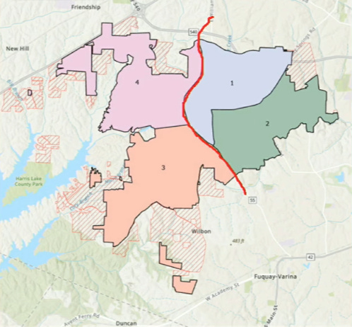
Each new zone covers a cluster of neighborhoods and key community sites:
Zone 1 (Northwest): Arbor Creek, Sunset Ridge North, Oak Hall, Windward Pointe, and Woodcreek; includes UNC Rex Holly Springs Hospital and Ting Park.
Zone 2 (Northeast): Holly Park, Main Street Square, Somerset Farms, Sunset Oaks, and Sunset Ridge; includes Sunset Commons Shopping Center and Womble Park.
Zone 3 (Southwest): Harrison, Holly Glen, Honeycutt Farms, Morgan Park, Trinity Creek, and Wildwood; includes Holly Springs High School and the Walmart shopping area.
Zone 4 (Southeast): Carolina Springs, Forest Springs, 12 Oaks, Town Center Shopping Center, and the town’s growing biomanufacturing corridor.
Each patrol shift will assign two officers per zone, plus a “district” or float car on each side of the bypass to provide backup when needed. A sergeant and a corporal will supervise the squad of 12 patrol officers per shift.
Data-Driven Design
Liquorie credited the department’s crime analyst, Kassie Langdon, for mapping dispatch data, growth projections, and geography to create zones that balance call volumes. The goal, he said, is to keep officers’ “non-discretionary” workload — emergency or dispatched calls — under 60 percent of their total shift time.
“In Holly Springs, we’re fortunate,” he said. “Right now, only about 25 percent of our officers’ time is tied to mandatory calls, which leaves room for community policing and proactive patrols.”
The new configuration accounts for where the town is growing fastest, particularly around Carolina Springs and along the Piney Grove-Wilbon corridor, ensuring the map can expand as development continues.
Community and Safety Benefits
Liquorie highlighted several expected improvements:
Faster response times: Officers will be stationed closer to calls and won’t need to cross NC-55 Bypass as often.
Greater community connection: Permanent zone assignments will foster “zone pride,” allowing officers to build relationships and recognize residents.
Enhanced officer safety: The built-in partner system means quicker backup for high-risk or two-officer calls.
Balanced workload: Call volumes and growth projections have been evenly distributed to prevent overburdening any one area.
Better coverage: The structure provides 24-hour coverage with built-in flexibility when officers leave their zones for arrests, reports, or breaks.
Implementation Early 2026
The four-zone model is already being programmed into the county’s computer-aided dispatch (CAD) system. Once the new map is loaded and tested, the department plans to go live around the first week of January 2026.
Liquorie said his team will monitor call patterns and response times closely during the first months and make adjustments as needed.
“We’ll be able to demonstrate it both quantitatively and qualitatively,” Kassie Langdon added, referencing ongoing data analysis.
A Proactive Step for a Growing Town
While no Council action was required, members praised the department for its forward-thinking approach. The change, they agreed, reflects a town preparing for its continued growth without sacrificing safety or service quality.
“This plan gives officers ownership and gives residents a familiar face,” one Council member remarked. “That’s what community policing is all about.”
Typo for Zone 1 listing. Should be Arbor Creek.